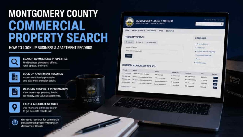
Working with the public data infrastructure for commercial real estate requires a highly specialized approach. Unlike looking up a standard single family home, analyzing retail plazas, industrial warehouses, or multi family apartment complexes involves decoding intricate layers of business entities, land usage classifications, and structural valuation tiers. For commercial brokers, real estate investors, and local developers operating within the Dayton metro area, extracting this data cleanly is the first step toward accurate underwriting. The official portal provided by the county offers robust tools to uncover these assets, provided you know how to use the system’s corporate filters. This comprehensive guide details how to execute a professional Montgomery County commercial property lookup, run a targeted business parcel search Dayton, and extract high value multi family property records.
The Administrative Role of the Montgomery County Auditor in Commercial Real Estate
In the state of Ohio, the County Auditor acts as the absolute regulatory authority for checking, recording, and assessing commercial tangible real estate assets. While residential assessments focus heavily on neighborhood sales comparisons, the Auditor’s commercial appraisal division utilizes complex income capitalization models and localized replacement cost analytics to establish property baselines. The Auditor serves several critical roles that directly assist commercial real estate researchers.
- Classifies Land Usage.
The Auditor strictly assigns statutory Ohio land use codes (such as Class 400 for Commercial and Class 500 for Residential/Multi family) to ensure fair legal zoning classifications. - Logs Corporate Tax Responsibilities.
By linking physical parcels to registered corporate entities, LLCs, and holding companies, the Auditor maintains absolute financial transparency. - Tracks Real Estate Conveyances.
Every major commercial deed transfer, institutional mortgage reference, and conveyance fee sheet is logged publicly to prevent administrative real estate fraud.
Step by Step Guide to Executing a Business and Commercial Property Search
Commercial assets are rarely registered under an individual’s personal name. They are typically held under corporate shells or structural liability partnerships. To bypass these data roadblocks, use this systematic approach on the official portal.
Step 1. Open the Commercial Search Command Center
Launch your web browser and go to the official web portal hosted by the Montgomery County Auditor. From the primary header header, enter the dedicated Property Search system application dashboard.
Step 2. Utilize the Advanced Corporate Search Filters
If you do not possess the precise numerical parcel identification numbers, execute your inquiry using corporate credentials. In the Owner Name query input field, enter the legal name of the business entity or real estate holding group (e.g., “Dayton Logistics LLC” or “Main Street Apartments LLC”).
Step 3. Screen via the Ohio Statutory Land Use Code
To isolate large scale multi family apartment complexes or retail strip malls from standard properties, look at the generated search summary results. Filter or verify the results using the three digit Ohio property class codes to guarantee you are viewing commercial grade data.
Step 4. Extract the Commercial Valuation and Structure Records
Once you click on the specific commercial parcel, move away from the basic profile summary. Click directly on the Land tab to view commercial acreage metrics, or select the Card/PRC link to view specific commercial structural data, including total rentable units, loading dock counts, and foundation square footage.
Understanding Commercial Valuation and Usage Fields on the Auditor Site
When pulling up data sheets for commercial complexes or large apartment tracts, you will encounter unique data points. The three column table below breaks down the primary fields found during a commercial land valuation search.
| Technical System Field | Administrative Definition | Real Estate Broker Application |
| Ohio Land Use Code (LUC) | A specific three digit state classification number identifying the primary operational activity on the land (e.g., 429 for Strip Shopping Centers, 401 for Apartments with 20+ units). | Helps brokers instantly verify if a parcel is classified for heavy industrial use, retail use, or multi family housing. |
| Total Card Living/Use Units | The officially recorded internal unit count or net rentable square footage breakdown registered inside the county database. | Essential for multi family investors to audit tenant unit counts against official county records during due diligence. |
| CAUV / Commercial Valuation | The appraised financial baseline valuation calculated via commercial cost approaches or neighborhood income stream capitalization models. | Used by commercial underwriters to determine baseline property tax projections before completing a real estate acquisition. |
Extracting Multi Family Property Records for Investment Due Diligence
When analyzing apartment buildings containing four or more individual rental units, the data behaves differently inside the Montgomery County property search system. Large apartment tracts are often split across multiple contiguous parcel identification numbers to separate distinct phases of a complex or split residential components from commercial parking zones.
When conducting a commercial land valuation search on multi family assets, experts always cross reference the original subdivision plat maps via the integrated GIS viewer. This step ensures that accessory assets such as private retention ponds, leasing offices, and independent carports are bundled correctly into your investment valuation spreadsheets.
Conclusion
Understanding the specialized Montgomery County commercial property lookup framework is mandatory for anyone looking to acquire, develop, or broker business real estate within the Dayton region framework is mandatory for anyone looking to acquire, develop, or broker business real estate within the Dayton region. By leveraging the official Auditor tools to dissect corporate ownership names, track land use codes, and isolate asset valuations, you gain an elite edge in market intelligence. Utilizing this official public data report safeguards your commercial investments and guarantees your underwriting matches official county legal records. Keep this tactical guide close by for your next commercial property research project.
FAQs
How do I search for a commercial parcel if the owner name is hidden?
Execute your lookup using the exact site property address. The system summary card will immediately display the true registered corporate owner or corporate entity name holding the deed.
What does an Ohio Land Use Code starting with a “4” mean?
Any three digit code beginning with “4” designates a commercially zoned asset, such as retail stores, office buildings, medical medical centers, or multi family apartment buildings.
Can I track historical commercial lease documents on the Auditor’s portal?
No. The Auditor tracks structural ownership records and land valuation metrics. To find specific commercial lease agreements or tenant documents, check the County Recorder’s office.
Why does a large multi family apartment complex show multiple distinct parcel numbers?
Large apartment developments are often subdivided by developers for financing reasons, separating distinct structural phases, communal leasing offices, or detached garage blocks into independent tax parcels.
How often does the Auditor adjust commercial property valuations online?
Commercial property valuations undergo a comprehensive county wide reassessment every six years, with minor statistical data updates applied during three year triennial review cycles.